

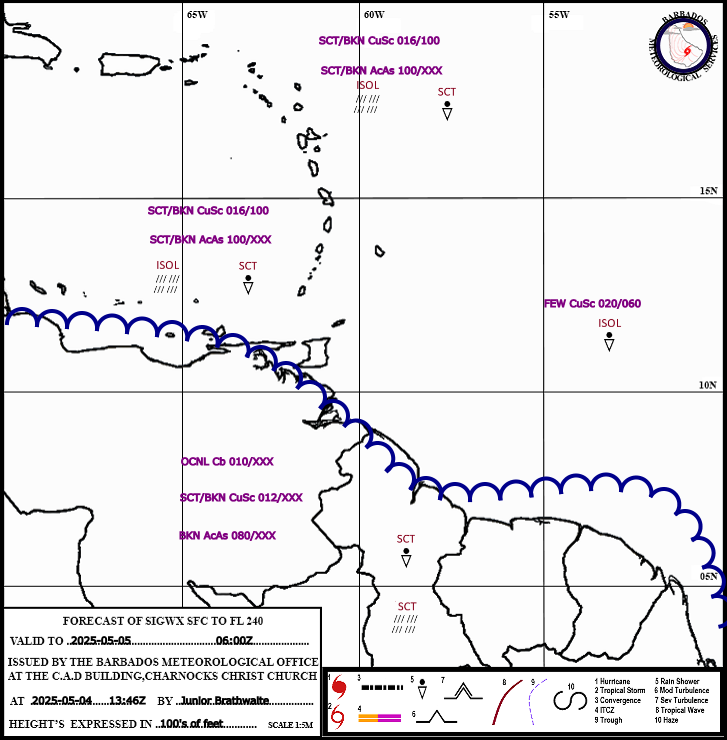
Weather Update:
Donations
-
Help us to continue our progressive development,we appreciate your kind donation.
Advertisements

Follow Us On Social Media
Aviation
BMS Cam Tower
Model Products
Radar Composites
Barbados Climate Predictions
Lastest Weather Information
Extended Forecast
General Information
Tropical Weather Discussion
Expires:No;;945125
AXNT20 KNHC 052359
TWDAT
Tropical Weather Discussion
NWS National Hurricane Center Miami FL
0015 UTC Sun Jul 06 2025
Tropical Weather Discussion for North America, Central America
Gulf of America, Caribbean Sea, northern sections of South
America, and Atlantic Ocean to the African coast from the
Equator to 31N. The following information is based on satellite
imagery, weather observations, radar and meteorological analysis.
Based on 1800 UTC surface analysis and satellite imagery through
2345 UTC.
...SPECIAL FEATURES...
Tropical Storm Chantal is centered near 31.9N 78.7W at 05/2100
UTC or about 80 nm SE of Charleston South Carolina, moving N at
6 kt. Estimated minimum central pressure is 1006 mb. Maximum
sustained wind speed is 40 kt with gusts to 50 kt. Tropical
storm force winds reach to within 120 nm in the SE quadrant.
Seas within about 120 nm in the NE quadrant are in the range of
9 to 18 ft (3 to 5.5 m). Deep convection in the form of the
numerous to strong-type intensity is confined to the northeast
and east of Chantal from 30N to 34N between 74W and 78W. A
motion toward the north-northwest is expected to begin this
evening, followed by a turn to the northeast by Sun night. The
tropical storm force winds in the SE quadrant will lift north of
31N by late tonight, allowing for seas just south of 31N to
subside to below 8 ft (2.5 m).
Please read the latest HIGH SEAS FORECAST issued by the National
Hurricane Center at website -
https://www.nhc.noaa.gov/text/MIAHSFAT2.shtml and the latest
Three NHC Forecast/Advisory and Public Advisory at
www.hurricanes.gov for more details.
Gale Warning E of 35W: A tight pressure gradient between a 1035
mb high pressure system located north of the Azores and low
pressures in northwest Africa will continue to support gale-force
NE winds with severe gusts and 7 to 10 ft seas, for the waters
between the Canary Islands, and vicinity waters until at least
07/0900 UTC according to Meteo France.
For more details, please visit the Meteo France High Seas Forecast
listed on the website https://wwmiws.wmo.int
...TROPICAL WAVES...
A far eastern tropical wave was added to the 18Z surface
analysis near 19W from 05N to 16N based on satellite animation
imagery and on the SUNY-Albany Tropical Trough Diagnostics. It
is moving westward at 5 to 10 kt. This wave is observed to be
embedded within a very moist and unstable environment. Numerous
moderate to strong convection is east of the wave from 07N to
14N. This activity reaches inland Africa. Scattered moderate to
isolated strong convection is west of the wave to near 25W from
07N to 10N.
An eastern Atlantic tropical wave has its axis near 33W from
07N to 19N, moving westward around 15 kt. A very dry and stable
atmospheric environment surround this wave. Only isolated
showers are seen near the southern part of the wave axis, where
it crosses the monsoon trough.
A central Atlantic tropical wave has its axis near 50W from 05N
to 18N. This wave was relocated farther west from earlier today
based on satellite animation imagery and on the SUNY-Albany
Tropical Trough Diagnostics. It is moving westward at 15 to 20
kt. This wave is also surrounded by a very dry and stable
atmospheric environment. Isolated weak showers are possible near
the southern part of the wave axis.
A central Caribbean tropical wave is along 73W extending from
extreme southern Haiti southward to inland far western Venezuela.
It is moving westward around 15 kt. Isolated showers and
thunderstorms are south of 13N to the coast of Venezuela between
70W and 75W.
The tropical wave that previously was along 89W has moved well
inland Central America, and is being described in the Eastern
North Pacific Tropical Weather Discussion.
...MONSOON TROUGH/ITCZ...
The monsoon trough enters the Atlantic through the coastal
border of Senegal and Gambia, then extends southwestward across
10N30W to 08N43W, where it transitions to the ITCZ and continues
westward to just north of Guyana near 09N50W. Scattered moderate
convection is within 120 nm south of the trough between 28W-32W.
...GULF OF AMERICA...
A trough extends southwestward from Tropical Storm Chantal
across central Florida to the southeastern Gulf. Another
trough curves northwestward from the northeastern Gulf to near
New Orleans. An upper-level low moving south-southwestward as
seen near 27N89W on water vapor imagery is helping to initiate
scattered showers and isolated strong thunderstorms over some
sections of the central and eastern Gulf. Elsewhere, a weak 1017
mb high is analyzed over the NW Gulf near 27N83W. Its associated
gradient is allowing for gentle to moderate north to northeast
winds and seas of 2 to 4 ft for the northeastern Gulf. Moderate
southeast to south winds along with seas of 2 to 4 ft are off
the Texas coast and in the Bay of Campeche. Light to gentle
winds and 1 to 3 ft seas prevail for the rest of the Gulf.
For the forecast, scattered showers and thunderstorms will
continue to develop along these troughs over the waters near
Florida. Weak high pressure will then prevail into early next
week. Fresh northeast to east winds will pulse along and just
north of the Yucatan Peninsula each afternoon and evening through
early next week as a trough develops inland daily and then
drifts westward over the Bay of Campeche at night.
...CARIBBEAN SEA...
High pressure of 1025 mb is analyzed well north of the area
near 32N58W. It is the main feature driving the trade-wind
regime for the eastern and central sections of the basin.
Moderate to fresh trades and seas of 4 to 6 ft are over the
southwestern, central and eastern basin while gentle to
moderate trades and seas of 1 to 3 ft are over the northwest
section of the sea.
Satellite imagery shows scattered to numerous moderate to strong
convection over most of Central America from Honduras southward.
Scattered moderate convection is over some sections of central
and eastern Cuba and just southwest of Jamaica.
For the forecast, the pressure gradient between the Atlantic
ridge and the Colombian low will continue to support pulsing
fresh to strong trades and rough seas across the south-central
Caribbean through the forecast period. Moderate to fresh winds
and moderate seas are expected in the eastern Caribbean while
gentle to moderate winds and slight to moderate seas will prevail
elsewhere, with the exception of fresh to strong east winds in
the Gulf of Honduras Sun night and Mon night.
...ATLANTIC OCEAN...
Please see the Special Features section for details on Tropical
Storm Chantal and a Gale Warning issued by Meteo-France for the
Canary Islands.
Convergent southerly winds are generating widely scattered
showers and isolated thunderstorms from the NW Bahamas northward
to beyond 31N between 73W and the Florida/southern Georgia coast.
A trough extends from near 28N61W to 25N69W. Satellite imagery
shows scattered moderate convection from 24N to 27.5N between
61W and 66W, and just offshore the central Cuban coast over the
Straits of Florida between 79W and 81W.
Fresh to strong south to southwest winds along with seas of
7 to 11 ft are present north of 28N and west of 75W. Otherwise,
the subtropical ridge is sustaining gentle winds with 3 to 4 ft
seas north of 26N between 40W and Florida/southern Georgia coast.
Farther east between 35W and 40W as well as farther south from
10N to 26N between 35W and the Lesser Antilles/Bahamas, gentle
to moderate northeast to east winds and seas of 4 to 7 ft exist.
Gentle winds and seas at 3 to 5 ft in mixed swell continue
elsewhere across the basin.
For the forecast west of 55W, Tropical Storm Chantal is near
31.9N 78.7W at 5 PM EDT, and is moving north at 6 kt. Maximum
sustained winds are 40 kt with gusts to 50 kt, and the minimum
central pressure is 1006 mb. Chantal will move to near 33.0N
79.3W Sun morning, weaken to a tropical depression near 34.1N
79.6W Sun afternoon, inland to 35.3N 79.0W Mon morning, and
dissipate Mon afternoon. High pressure will prevail elsewhere.
This pattern will support generally gentle to moderate winds
except for moderate to fresh winds off the northern coast of
Hispaniola through Mon.
$$
Aguirre