

Weather Update:
Donations
-
Help us to continue our progressive development,we appreciate your kind donation.
Advertisements

Follow Us On Social Media
Aviation
BMS Cam Tower
Model Products
Radar Composites
Barbados Climate Predictions
Lastest Weather Information
Extended Forecast
General Information
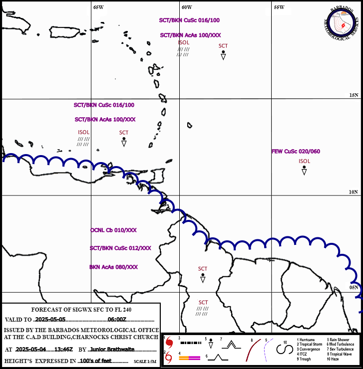
| Barbados Meteorological Services Charnocks ChCh Weather Discussion http://www.BarbadosWeather.org Initial to 4 days discussion based on Satellite imagery,BMS Radar composite,S.P.I.E products,GEM, GFS, WW3, UKMET and BMS WRF modeling, surface and upper air observations, Satellite derived products. DATE: 20260802 PERIOD: Evening |
|
Eastern Caribbean ****************** TROPICAL WAVES AT 1800 UTC / 2 PM LST **************************** A Tropical wave was analyzed near 63/64W south of 13N, moving westward at 20 knots. A trough was analyzed within the monsoon near 30W south of 25N. It has an associated 1012mb low located near 17N 29W. ******************************************************************************************** Moisture and instability trailing the tropical wave near 64W maintained some deep convection, scattered showers, and isolated thunderstorms across Trinidad, Tobago, and the southern Windwards. Similar conditions were experienced across the northermost Leewards, due to a passing low-level trough. Across Barbados and the remainder of the island chain, a ridge pattern regained dominance, bringing sunny conditions which were only interrupted by a few brief periods of cloudiness and light showers. Here at Charnocks, Christ Church, 2.1mm or rainfall was measured, while across the island most rainfall occurred in the south, with a maximum accumulation of 6.2 recorded in Christ Church. Across the Guianas, an initially fair morning gave way to a cloudy afternoon with scattered showers, and a few isolated thunderstorms along coastal areas. Winds across the region were generally moderate, peaking in Barbados with a sustained wind of 18 knots and a gust of 29 knots. Seas remain slight to moderate with swells of 1.0m to 2.0m in open water. |
|
Western Caribbean Across Puerto Rico and Hispaniola, scattered showers and isolated thunderstorms occurred as the low-level trough continued westward, under the supportive upper-level flow. Elsewhere, the combination of low-level perturbation and upper-level Low maintained intermittent cloudiness and showers. Additional instability came during the afternoon, with diurnal heating and localized effects generating deep convection and occasional thunderstorms. |
|
Eastern Caribbean Outlook Tonight: A mixture of fair skies and periods of cloudiness and light showers is expected as the ridge pattern will remain dominant across Barbados and the island chain. Barbados Forecast Max/Min Temps: 27/24. Monday: The Atlantic high-pressure system will be dominant over the eastern Caribbean. Fair to partly cloudy skies are forecast with light showers possible mainly over the Leewards and the extreme southern Windward Islands. Barbados Forecast Max/Min Temps: 32/24. Tuesday: A surface to low-level trough will bring a few showers to the Leeward Islands. Elsewhere, similar weather conditions are expected as a ridge pattern remains dominant. Barbados Forecast Max/Min Temps: 32/24. Wednesday: The low-level trough will exit the Leewards and a ridge pattern will be dominant across the region. Fair to partly cloudy skies with a few passing light showers are forecast for the islands. Barbados Forecast Max/Min Temps: 32/24. Thursday: The potential for brief showers remains across the island chain as perturbations within the ridge flow traverse the region. Barbados Forecast Max/Min Temps: 32/24. |
|
Western Caribbean Outlook Tonight: The afternoon's deep convection, scattered showers, and thunderstorms will persist into the early hours of the night due to the supportive upper-level flow. Afterward, low-level perturbation will continue to be enhanced by the upper-level Low, with occasional showers and thunderstorms expected as a result. Monday: Unsettled weather will persist across the region, especially during the afternoon. Tuesday: Troughing across the western Caribbean will maintain unsettled weather over parts of Cuba, Jamaica, and the Bahamas. Elsewhere, a ridge pattern will be dominant. However, low-level perturbations may trigger occasional light showers, especially during the afternoon. Additionally, the upper-level flow will remain supportive. Wednesday: Another area of troughing will approach from the east, moving across Puerto Rico, Hispaniola, and the southern Bahamas. With the support of the upper-level flow, cloudy skies, occasional moderate showers, and thunderstorm activity are likely. Thursday: Partly cloudy skies and light showers are expected across Puerto Rico and the Virgin Islands as the trough continues westward, and the ridge pattern regains dominance. Elsewhere, no significant change is expected. |
| Meteorologist Nkosi Mounter-Taitt |