

Weather Update:
Donations
-
Help us to continue our progressive development,we appreciate your kind donation.
Advertisements

Follow Us On Social Media
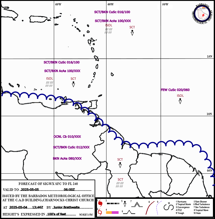
Aviation
BMS Cam Tower
Model Products
Radar Composites
Barbados Climate Predictions
Lastest Weather Information
Extended Forecast
General Information
Tropical Weather Discussion
Expires:No;;521280
AXNT20 KNHC 022231
TWDAT
Tropical Weather Discussion
NWS National Hurricane Center Miami FL
0015 UTC Mon Aug 3 2026
Tropical Weather Discussion for North America, Central America
Gulf of America, Caribbean Sea, northern sections of South
America, and Atlantic Ocean to the African coast from the
Equator to 31N. The following information is based on satellite
imagery, weather observations, radar and meteorological analysis.
Based on 1800 UTC surface analysis and satellite imagery through
2230 UTC.
...TROPICAL WAVES...
An eastern Atlantic tropical wave is along 31W, south of 20N,
moving westward at 10-15 kt. Scattered showers and isolated
thunderstorms are present from 06N to 10N and between 30W and
35W.
An eastern Caribbean tropical wave is along 63W, south of 17N,
moving westward at 15-20 kt. Scattered showers and thunderstorms are
active over northeastern Venezuela.
A western Caribbean tropical wave is along 81W, south of 19N,
moving westward at 10-15 kt. Scattered showers and thunderstorms
are active off Nicaragua and Costa Rica.
...MONSOON TROUGH/ITCZ...
The monsoon trough enters the Atlantic through the coast of
Mauritania near 19N16W and dives southwestward to a 1011 mb low
pressure near 16N30W and then to 10N45W. No significant convection
is evident other than already described in the Tropical Wave
section.
...GULF OF AMERICA...
A stationary front reaches from Mobile Bay, Alabama across the far
northwest Gulf to Galveston Bay, Texas. Scattered showers and
thunderstorms are active across the northern Gulf from Texas to
the Big Bend area of Florida. The Atlantic ridge extends east to
west along roughly 24N, from the Florida Straits to the coast of
Tamaulipas in northeast Mexico. This pattern is supporting
moderate to fresh SW to W winds north of 28N where seas are 3-5
ft, and gentle to moderate breezes and 1-3 ft seas elsewhere.
For the forecast, relatively weak high pressure will remain in control
of the weather pattern across the Gulf, promoting gentle to
moderate winds into the upcoming week. The exceptions will be
fresh NE to E winds off the northwest coast of the Yucatan
peninsula nightly through the period, as well as the far
northern Gulf, where a cold front approaching the coast will
help to induce moderate to fresh W to SW winds through Mon.
Scattered to numerous showers and thunderstorms are expected over
the eastern Gulf, and over the central Gulf N of 25N between 87W
and 92W into the upcoming week as a mid to upper-level trough and
a cold front approach the Gulf coast.
...CARIBBEAN SEA...
The westward- building subtropical high pressure system
positioned over the central Atlantic forces fresh to strong
easterly trade winds and rough seas over much of the central
Caribbean. Moderate to locally fresh easterly winds and moderate
seas are found in the eastern Caribbean. Elsewhere, moderate or
weaker winds and slight to moderate seas prevail.
For the forecast, the pattern will continue to support fresh to
strong trades over the central basin through much of the week
ahead. Fresh to strong winds will pulse in the Gulf of Honduras at
night Mon through Thu. A tropical wave, near 82W is helping to
enhance numerous showers and thunderstorms over the southwestern
Caribbean. The wave will move inland Central America late tonight
into early Mon.
...ATLANTIC OCEAN...
Favorable upper-level conditions and abundant tropical moisture
combine to produce scattered showers and isolated thunderstorms
between the northern Bahamas and Bermuda. Elsewhere, the tropical
Atlantic is dominated by a 1026 mb high pressure system centered
near 33N56W, supporting fresh to locally strong southerly winds
and seas of 4-6 ft north of 28N and west of 75W. Elsewhere,
moderate or weaker winds and moderate seas prevail across much of
the remaining tropical Atlantic.
For the forecast west of 55W, the pattern will change little through Tue,
then lift north to central Florida on Wed and north of 31N on
Thu. The pressure gradient between the ridge and a cold front
moving through the southeastern U.S. will continue to support
fresh to strong SW winds ahead of the front, along with scattered
to numerous showers and thunderstorms over the majority of the
area well into the upcoming week. Fresh to strong trades will
pulse just north of Hispaniola at night through the period.
$$
Christensen